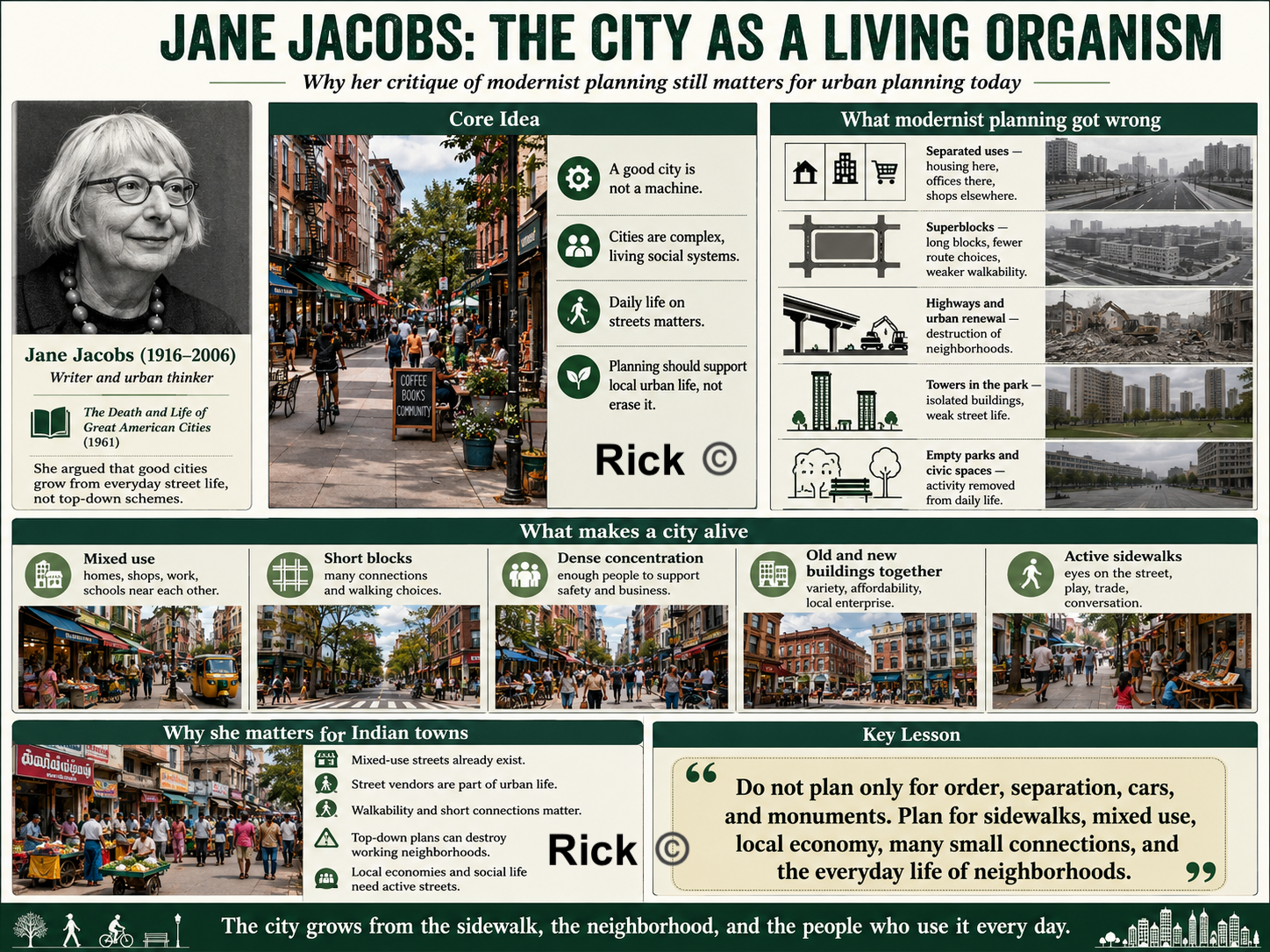
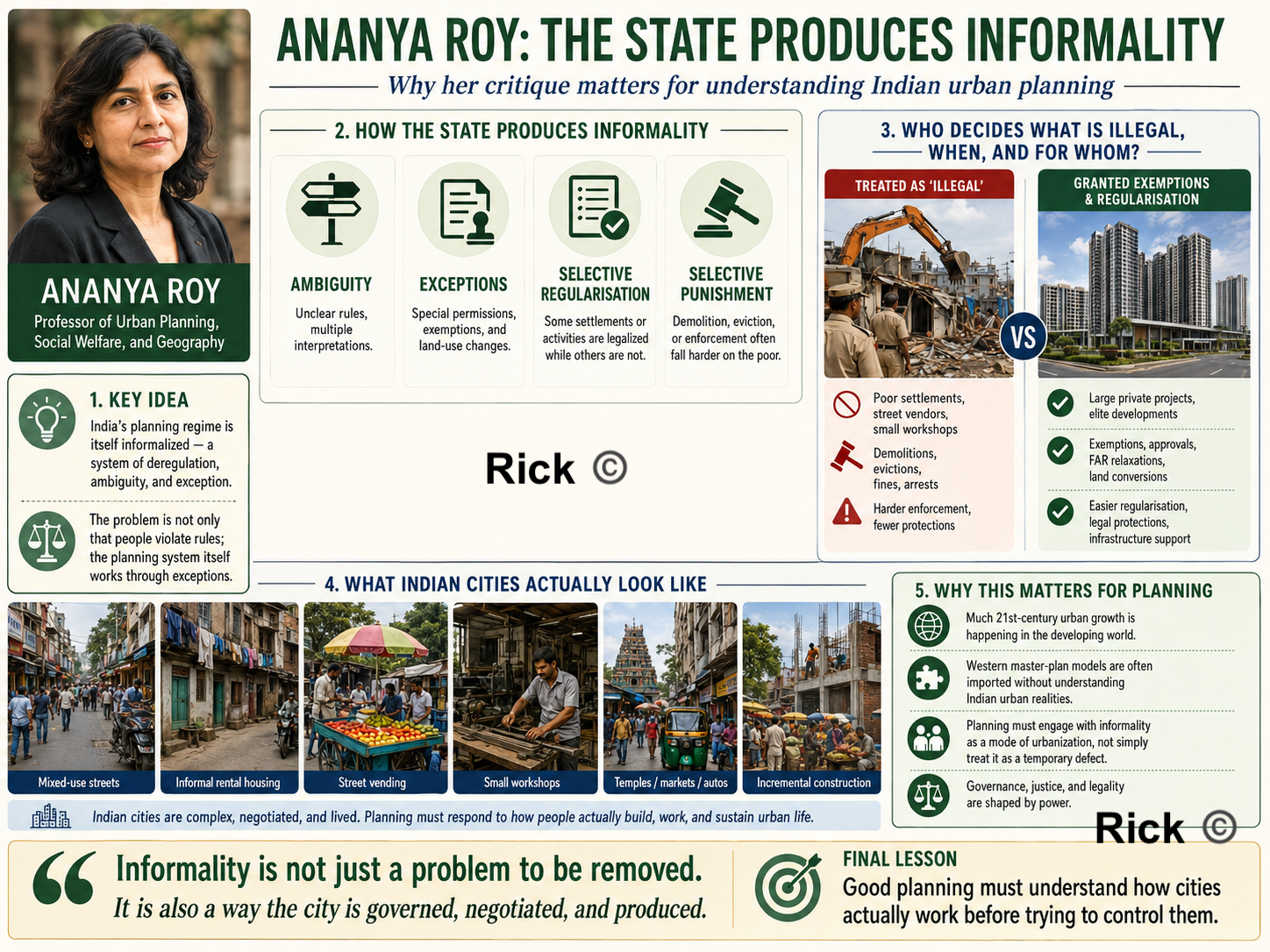
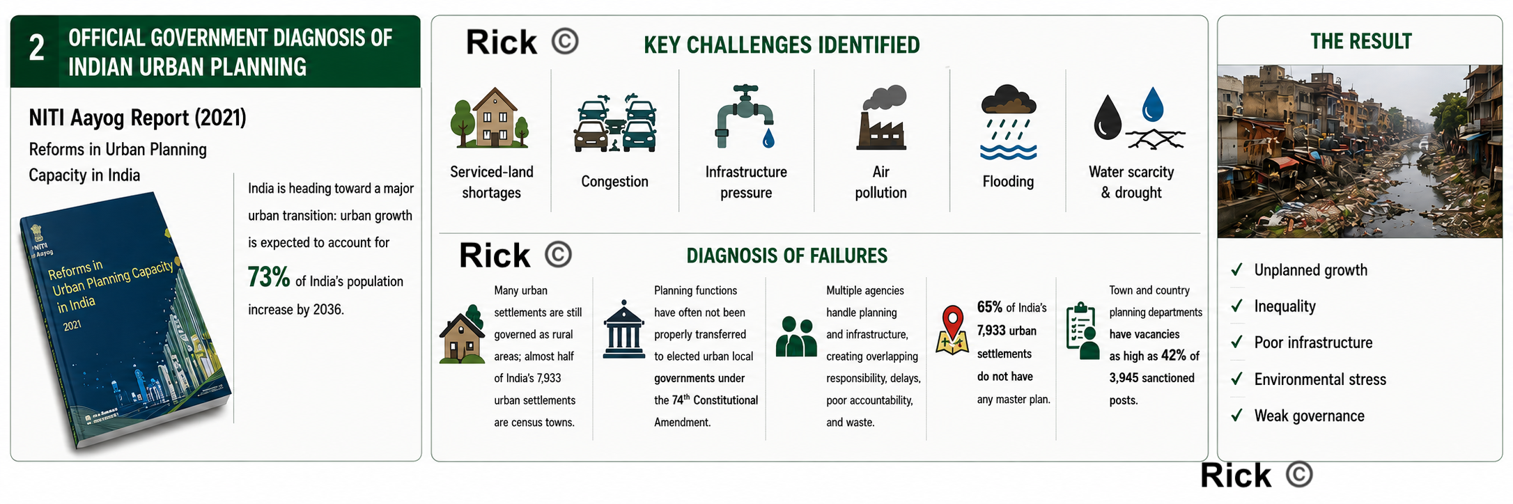
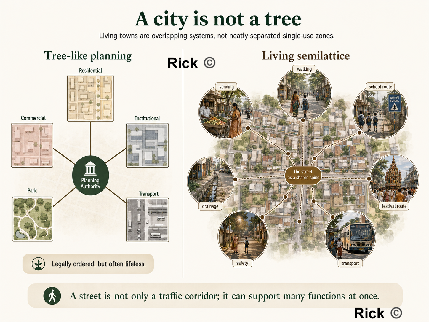
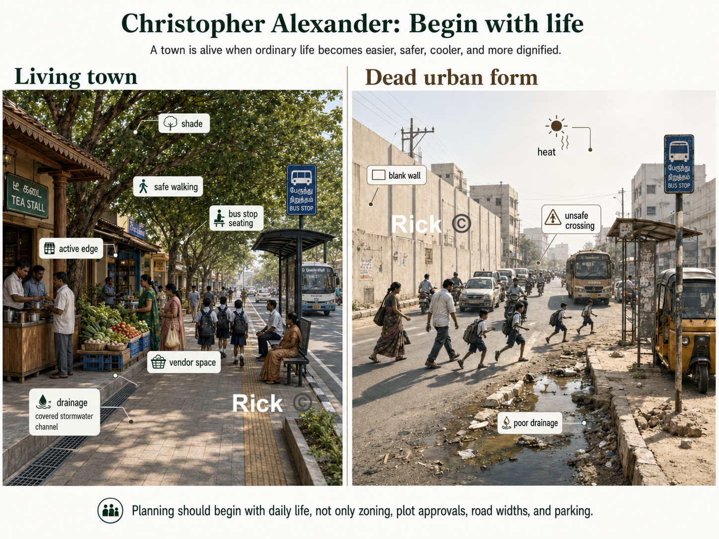
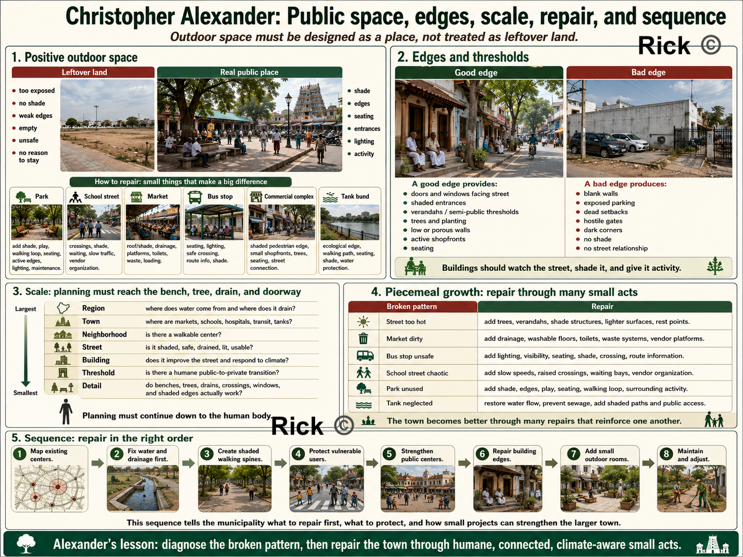
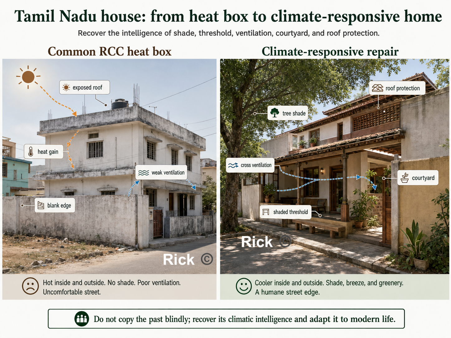
Why are South Indian towns underperforming?

Theories, Tirunelveli Case Study, and a Repair Sequence

Rick Rejeleene

July 5, 2026

Urban Planning in South India

Issues, theories, Tirunelveli, and a Repair Sequence

I began with a simple question,

Why are so many South Indian towns poorly planned?

The easy answers are “bad roads” “missing parks” or “more trees”.

What I found was a chain of linked causes: land use, water, mobility, finance, governance, and maintenance are not treated as one delivery system.

Main argument

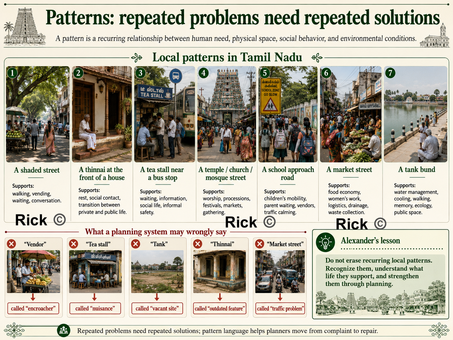
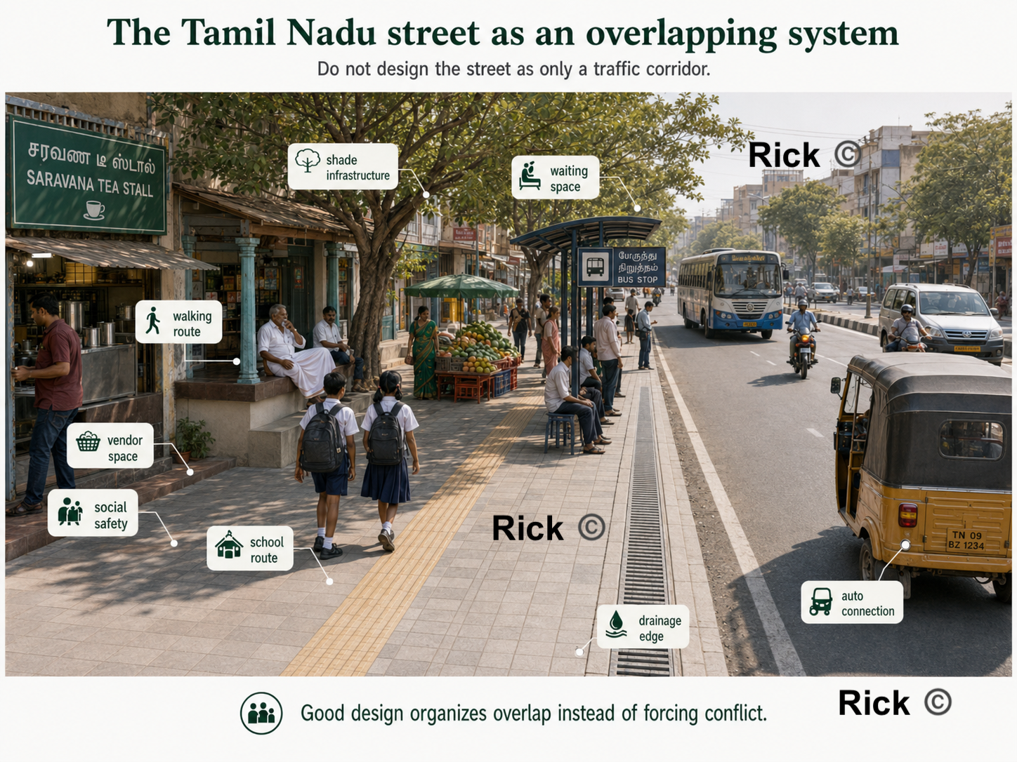
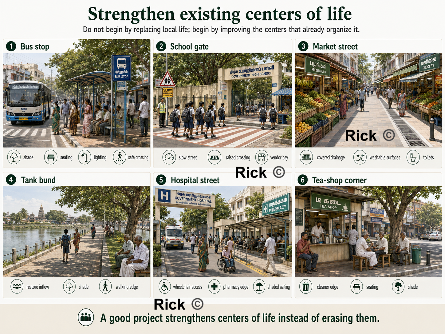
A livable city requires integration of land, water, movement, public life, and delivery capacity.

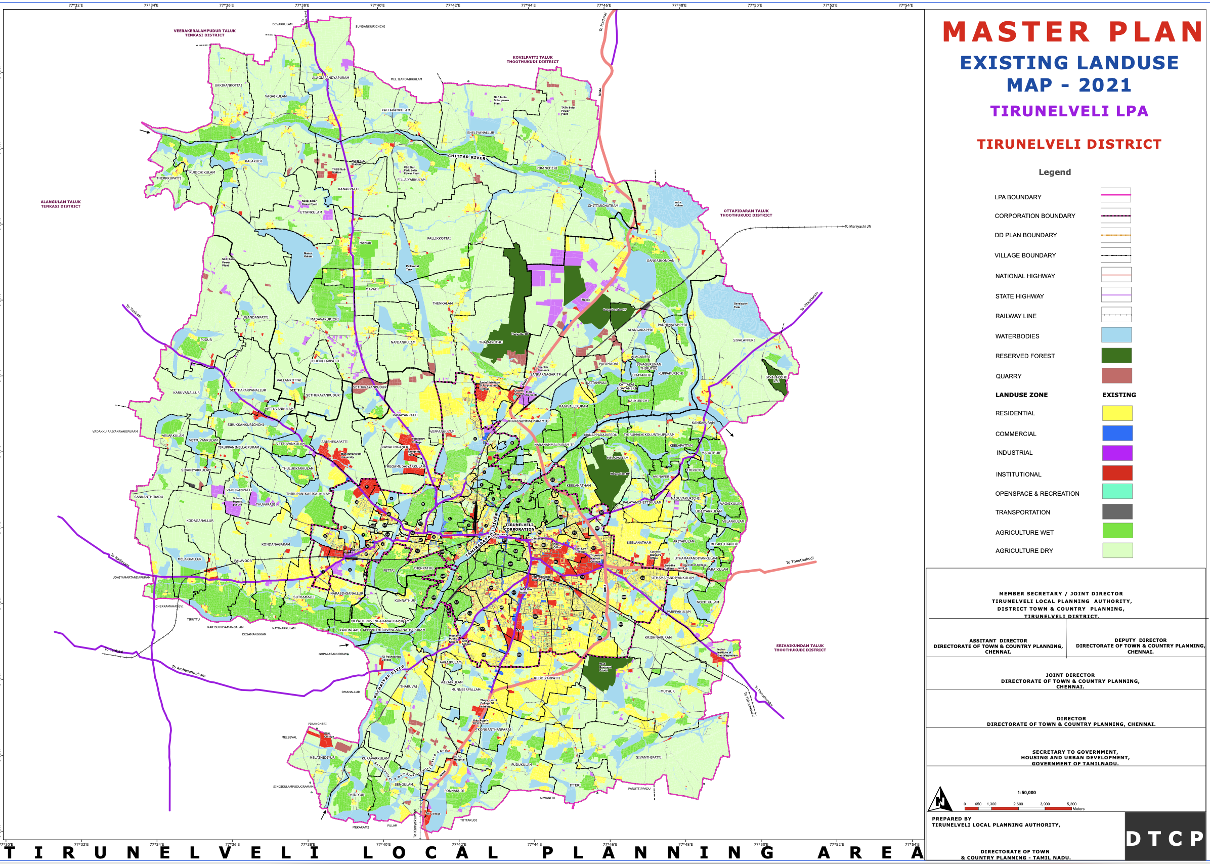
A city becomes functional when these layers are planned, maintained and works together:

Physical system Social system Delivery system
Land use, roads, buses, footpaths, drainage, tanks, sewage, parks Housing, schools, markets, worship streets, vendors, jobs, daily movement Finance, staffing, enforcement, maintenance, public monitoring

The post moves from master plan as map to master plan as delivery system.

Three families of underperformance

Family What it means What it produces
Planning mindset The city is treated like a coloured land-use sheet, not a living system. Roads without shade, parks without users, layouts without centres.
Missing planning layers Mobility, drainage, density, heat, public realm, sewage, finance, and maintenance are not fully integrated. Congestion, flooding, unsafe walking, weak public spaces, unreliable services.
Weak delivery system Authority, money, staff, enforcement, and maintenance sit in different hands. Plans look correct, but implementation underperforms.

Urban planning theories

The theoretical spine of this work

Each theory and thinker gives a practical lens to apply

Thinker Core idea Use for South Indian towns
H. V. Lanchester Emulate, not imitate. Adapt planning principles to Indian climate, finance, civic life, and local institutions.
Patrick Geddes Survey before plan. Study place, work, and folk before drawing projects.
Otto Koenigsberger Climate must shape design. Heat, shade, ventilation, rain, and materials are planning issues.
Ananya Roy Informality is produced by the state too. Ask who gets punished, regularised, exempted, or ignored.
Jane Jacobs Street life is evidence. Mixed use, active edges, short blocks, and local economy matter.
Christopher Alexander Cities are living structures. Repair centres, patterns, edges, outdoor space, and everyday dignity.

Lanchester and Geddes

Lens Planning lesson Tirunelveli translation
Lanchester Civic order needs drainage, housing, open space, roads, finance, and administration. Do not copy European form; adapt principles to Tamil climate, tanks, markets, streets, and civic capacity.
Geddes Survey before plan: diagnose before intervention. Map tanks, fields, bus routes, schools, markets, religious streets, flood paths, and daily movement first.

Start with what’s already working in South Indian town of Tirunelveli.

Koenigsberger: Climate is infrastructure

In South India, heat, humidity, glare, monsoon rain, ventilation, and shade decide whether streets, houses, markets, bus stops, schools, and parks actually work.

Planning question Design implication
Can people walk at noon? Shade trees, verandahs, arcades, rest points, lighter surfaces.
Where does rainwater go? Drainage slopes, desilting, tank protection, stormwater routes.
How does air move? Cross-ventilation, courtyards, street orientation, building spacing.
Which surfaces trap heat? Roof protection, shaded west walls, vegetation, cool materials.

Jane Jacobs: street life as evidence

Key question

Does the street support everyday life?

A good city is not only ordered from above. It is also shaped by mixed use, active streets, short blocks, local shops, children, elders, vendors, and “eyes on the street.”

Ananya Roy: informality

Key question

Who decides what is illegal, when, and for whom?

Planning can create informality through ambiguity, exception, and selective enforcement.

NITI Aayog: official diagnosis

Diagnosis

Fragmented planning, missing master plans, vacancies, and weak capacity.

The problem is not only urban growth. It is weak planning capacity and fragmented authority.

Alexander: city as semilattice

Key Idea

A city is overlapping systems, not isolated zones.

A living city is not a simple tree of residential here, commercial there, roads elsewhere.

Alexander: planning with life

Key test

Does ordinary life become easier, safer, and more beautiful?

Planning must begin with children, elders, women, vendors, shade, water, markets, and walking.

Alexander: local patterns and street overlap

Local patterns

Tamil towns already have life: markets, bus stops, tanks, worship streets, schools.

Street as overlap

A street is walking, vending, drainage, shade, delivery, safety, and social life.

Alexander: repair existing centres

Repair principle

Strengthen centres that already exist.

Repair bus stops, markets, school gates, tank bunds, worship streets, and tea corners.

Alexander: outdoor space and housing

Positive outdoor space

Public space must be shaped, shaded, entered, watched, used, and maintained.

Climate housing

Recover verandahs, courtyards, shade, thresholds, ventilation, and humane street edges.

Alexander’s first test for South Indian towns

Question Why it matters
Can children walk safely to school? A town that endangers children is not well planned.
Can elderly people sit in shade? Walking requires rest, shade, and dignity.
Can women wait safely for buses? Public transport is also lighting, visibility, toilets, and seating.
Can vendors earn without being erased? Informal work needs physical structure, not only eviction.
Can rainwater drain? Drainage is not a technical afterthought; it shapes everyday life.
Can people gather in the evening? Public life needs shaded, safe, and maintained places.

Tirunelveli case study

What the 2021 land-use map shows

The existing land-use map shows Tirunelveli as a larger city-region:

  • Tirunelveli–Palayamkottai dense core
  • outward residential expansion
  • commercial concentration in older centres
  • institutional clusters
  • road-corridor growth
  • agricultural landscape
  • tanks, channels, water bodies
  • selected industrial pockets

Tirunelveli existing land use map 2021

Land-use legend table

Colour / Symbol Meaning Planning question
Yellow Residential Are homes connected to schools, shops, buses, parks, water, and sewage?
Blue Commercial Does commerce create walkable centres or congested strips?
Purple / Magenta Industrial Are truck routes, buffers, waste, water, and worker access planned?
Red Institutional Are schools, hospitals, colleges, and public offices safely accessible?
Cyan Open space / recreation Are parks shaded, maintained, entered, watched, and used?
Grey Transportation Does the road network support walking, buses, freight, and safety?
Bright green Wet agriculture Is irrigated land protected as food, water, and flood infrastructure?
Pale green Dry agriculture Is peri-urban growth managed without scattered sprawl?
Light blue Water bodies Are tanks, canals, ponds, and rivers protected as blue infrastructure?

Numbers to remember

Metric Number Why it matters
2011 LPA population 7.34 lakh Baseline population for planning.
Projected 2041 population 9.56 lakh More housing, water, sewage, transport, and land pressure.
Projected water demand 130.32 MLD Water planning must match growth.
Projected sewage generation 104.26 MLD Sewerage capacity and treatment are central, not optional.
Proposed block cost ₹7,557.83 crore Implementation depends on phasing, agencies, and finance.
Coimbatore municipal bond raise ₹150.85 crore Shows why own-source revenue and credible borrowing matter.

What does the map require?

A land-use map shows us what land is used for. It does not tell us whether the city’s urban planning works.

Missing questions Why it matters
Are there continuous footpaths? Walking is the base layer of daily urban life.
Are streets shaded? Heat makes mobility and public life unequal.
Does drainage work during rain? Flooding is a planning failure, not only a weather event.
Is sewage treated before discharge? Sewerage protects tanks, canals, groundwater, and rivers.
Are buses accessible and reliable? Transport shapes access to schools, jobs, hospitals, and markets.
Are parks actually usable? Open space must be designed and maintained, not leftover.

Patterns seen in a South Indian town:Tirunelveli

Pattern 1: Growth follows roads

Existing pattern Consequence Better planning direction
Housing layouts, shops, petrol bunks, colleges, marriage halls, warehouses, and workshops grow along roads. The same road becomes highway, market street, bus route, parking area, and pedestrian space. Move toward centres-and-corridors planning.
Development spreads in strips instead of neighbourhood centres. Long trips, congestion, weak local public life. Build local centres around transit, schools, markets, parks, and services.
Roads become the main development logic. Planning reacts after congestion appears. Plan land use, mobility, drainage, and utilities together before conversion.

Pattern 2: The Old core is overloaded

When outer residential areas lack strong local centres, everyone keeps depending on the old core.

Result What it means
Congestion in historic streets Old streets carry too many functions without redesign.
Pressure on central markets and institutions Economic and institutional life remains too centralized.
Longer daily trips Outer housing does not become complete neighbourhoods.
Unsafe walking and parking conflicts Streets become contested space.
Weak neighbourhood identity outside the core New areas become layouts, not places.

Pattern 3: Agriculture is not empty land

Agricultural land supports food production, livelihoods, groundwater recharge, flood absorption, cooling, village identity, and open landscape structure.

Common question Better question
Which agricultural land can be urbanized? Which agricultural land must remain part of the regional support system?
How fast can land be converted into layouts? Which lands protect water, food, flood storage, ecology, and rural livelihoods?
Where can the city expand cheaply? Where can growth happen without creating long-term infrastructure debt?

Pattern 4: Water bodies are infrastructure

Tanks, channels, wetlands, canals, and river edges are not decorative blue areas.

Water-body function Planning implication
Irrigation and groundwater recharge Protect inflows, outflows, catchments, and recharge zones.
Flood storage and stormwater movement Keep floodplains, low-lying land, channels, and tank chains open.
Cooling and public landscape Treat tank bunds and river edges as blue-green public space.
Pollution control Stop sewage, solid waste, and illegal discharge.
Ecology and memory Protect cultural and ecological identity, not only water volume.

A blue-green network must be mapped, protected, financed, maintained, and monitored.

Sewage is a chain

Link Failure mode Planning responsibility
House connection Homes not connected to the network. Connection drives, inspections, public communication.
Street sewer Blockage, leakage, illegal discharge. Maintenance, repair, monitoring.
Trunk sewer Capacity mismatch. Phasing and hydraulic design.
Pumping station Power failure, poor operation. Operations budget, backup power, staff.
STP Underperformance or bypassing. Performance monitoring, compliance, reuse planning.
Reuse / safe discharge Treated water not reused; polluted outfall. River protection, agriculture reuse, enforcement.

If any link fails, sewage enters stormwater drains, canals, tanks, groundwater, and the river.

Mobility: beyond road widening

The master plan includes road hierarchy, footpaths, accident data, traffic counts, public transport, ring road, bus shelters, pedestrian crossings, cycle tracks, freight management, and junction improvements.

The real test Users affected
Do footpaths connect continuously? Children, elderly people, disabled people, bus users.
Are school streets slowed and protected? Children, parents, teachers, vendors.
Are bus stops shaded, lit, and safe? Women, students, workers, patients.
Are freight and truck routes separated from local streets where needed? Residents, pedestrians, shops, schools.
Are junctions designed for people, not only vehicles? Everyone outside a car.

Delivery system

Finance: the core engine for maintenance and operations

When a city cannot fund maintenance, the master plan becomes a wish list.

Needed revenue engine Why it matters
Updated and collected property tax Backbone for local urban services.
Realistic water, sewage, and solid-waste user charges Keeps systems operating after construction.
Grants tied to measurable delivery Reduces symbolic projects and improves accountability.
Municipal bonds where revenue capacity is credible Helps finance large infrastructure, but requires trustworthy revenue.
Annual maintenance budgets Prevents roads, drains, parks, toilets, and lights from failing after inauguration.

Governance: who is responsible?

The plan and the power to carry it out often sits in different hands.

Fragment Problem
Planning authority May be state-controlled or chaired by appointed administration.
Municipal corporation Handles visible daily services but may not fully control statutory planning.
Line departments Water, highways, transport, electricity, drainage, and land can sit in different agencies.
Residents Experience the city as one connected system.

Fragmented authority is producing poor accountability resulting in ineffective maintenance and operations.

Two working models: Houten and Bay Village

A Dutch new town and a small American lakeside suburb show what a functioning delivery system looks like at town scale.

Houten, Netherlands (~50,000)

Planned from the 1970s around cycling and walking: a car ring road outside, direct bike and pedestrian routes inside, neighbourhood centres within a short ride of every home. Through-traffic never enters living streets.

Bay Village, Ohio, USA (~16,000)

An ordinary suburb that has a stable property-tax base, maintained parks and streets, walkable schools, and a local government residents can hold accountable.

Neither is a template to copy. Both pair a clear physical plan with the money, staff, and maintenance to deliver it — the combination South Indian towns could incorporate.

“But these are small, rich towns”: Why the comparison holds?

Neither town is used as a population-equivalent comparison. Both are used as Planning-Maintenance-Operation examples: proof that even small towns plan in layers, maintain and operate effectively.

Objection Answer
Bay Village has only ~16,000 people. That is the point. Even a town this small prepares a multi-layer plan, neighbourhood strengthening, connectivity, village-centre redesign, trails, bioswales, mixed-use development, and civic space, with public input and implementation priorities.
Houten is a wealthy Dutch new town. The goal is not wealth, it is learning the template of Sequencing, Maintenance and Operation. Houten decided its mobility hierarchy before growth, so every layout that followed inherited safe routes and local centres.
South Indian towns are larger and denser. Larger towns need more planning layers, not fewer. If a 16,000-person suburb plans connectivity and public space explicitly, a 9.5-lakh city-region requires more comprehensive planning, maintenance and operations.

I know Bay Village personally, which is why it appears here, it is planned, maintained, and operates efficiently.

How do Houten and Bay Village serve as models?

Stronger places usually have Tirunelveli needs
Clear land-use and mobility hierarchy Neighbourhood centres, not only ribbon growth.
Protected routes for vulnerable users Walkable school, market, hospital, and bus streets.
Park and open-space systems Usable, shaded, maintained public spaces.
Ward / neighbourhood-level service planning Local performance maps.
Reliable tax base Funded maintenance and credible borrowing.
Accountable local administration Clearer agency responsibility.
Long-term maintenance routines Drain, footpath, sewage, park, streetlight, and tank care.

Repair Sequence

Repair the city by connecting planning, infrastructure, finance, maintenance, and accountability.

The repair steps

Do first
Step Repair
1 Map centres: schools, markets, tanks, bus stops, clinics, worship streets.
2 Fix water, sewage, and drainage.
3 Create shaded walking spines.
4 Protect children, women, elderly people, disabled people, patients, and pedestrians.
Then build around it
Step Repair
5 Strengthen markets, bus stops, school streets, tank edges, and hospital streets.
6 Repair building edges and public outdoor spaces.
7 Fund maintenance, monitoring, enforcement, and service performance.

The rule: Do not approve layouts without infrastructure capacity.

Takeaway 1: What’s urgently needed for South Indian towns?

South Indian towns such as Tirunelveli need a delivery system.

Problem Meaning
Planning mindset The city is treated too much like a land-use colour map, instead of a living system of people, water, streets, markets, schools, housing, agriculture, and daily movement.
Missing layers Mobility, density, hydrology, heat, public realm, infrastructure capacity, social inequality, and growth phasing are not fully visible.
Weak delivery Authority, money, staff, enforcement, operations, and maintenance are split across different bodies.

The plan and the power to carry it out must come together.

Takeaway 2: The Repair Sequence

We’d need to move from master plan as map to master plan as delivery system.

Shift What it means
Map → Atlas Add mobility, water, sewage, stormwater, heat, density, public realm, finance, risk, and phasing layers.
Layout approval → Infrastructure capacity No growth without water, sewage, drainage, road access, schools, parks, public transport, and maintenance capacity.
Projects → Maintenance Build only what can be cleaned, repaired, funded, enforced, monitored, and operated over time.
Imitation → Local repair Strengthen Tamil urban life: tanks, markets, shaded streets, school streets, bus stops, vendors, agriculture, and neighbourhood centres.

A well-planned town is produced by engineering + finance + law + climate design + municipal capacity + democratic accountability.

Final Takeaway: The Test of Planning

The final test is whether residents living in the town feel safe, happy, served, and connected.

children walk safely women wait safely elders rest in shade vendors earn with dignity markets stay clean tanks carry water streets drain buses serve people homes stay cooler neighbourhoods function

For South Indian towns, the urban planning goal is to make the city livable, safe, serviced, shaded, walkable, climate-resilient, and accountable.